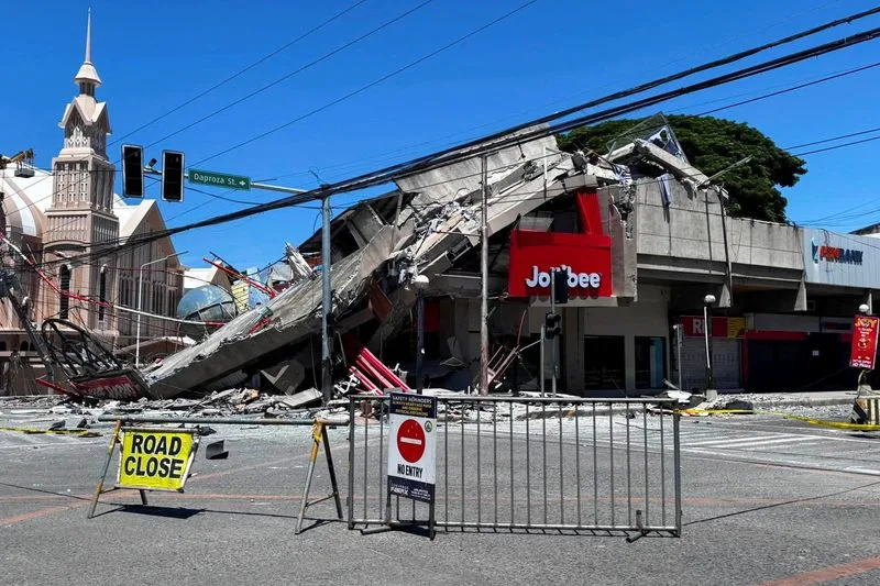
On June 8, 2026, a powerful magnitude 7.8 strikes rocked the southern Philippines, sending shockwaves through the island of Mindanao and beyond. The earthquake struck at approximately 7:37 a.m. local time, with its epicenter located about 13 kilometers (8 miles) southwest of General Santos City. This major seismic event has left communities reeling, with reports of collapsed buildings, widespread power outages, and at least 15 people feared killed amid ongoing rescue efforts.
The Philippines, situated along the Pacific Ring of Fire, is no stranger to earthquakes. However, the intensity of this magnitude 7.8 strikes event has drawn global attention due to its proximity to populated areas and the potential for secondary disasters like tsunamis. In this in-depth article, we explore the details of the quake, its immediate impacts, response efforts, and broader implications for seismic safety in the region.
What Happened: Timeline and Technical Details of the Magnitude 7.8 Strikes
The earthquake originated at a relatively shallow depth of around 10-34 kilometers, according to reports from the Philippine Institute of Volcanology and Seismology (PHIVOLCS) and the United States Geological Survey (USGS). A shallow focus often amplifies ground shaking, leading to more severe structural damage.
Initial reports indicated the magnitude fluctuating between 7.3 and 8.2 before settling at 7.8. The quake struck off Sarangani province, affecting Soccsksargen and Davao Region primarily. Within minutes, tsunami warnings were issued for coastal areas in the Philippines and neighboring countries, prompting urgent evacuations.
Key Facts at a Glance:
- Date and Time: June 8, 2026, 7:37 a.m. local time (23:37 GMT previous day)
- Magnitude: 7.8
- Epicenter: Southwest of General Santos City, Mindanao
- Depth: Approximately 10-34 km
- Casualties: At least 15-19 feared dead, over 100-130 injured (figures being verified)
- Aftershocks: Over 138 recorded, including one of magnitude 6.7
This magnitude 7.8 strikes event highlights the unpredictable nature of tectonic activity in the region.
Immediate Impacts: Damage, Casualties, and Humanitarian Concerns
The hardest-hit area was General Santos City, a bustling urban center with around 722,000 residents. Buildings collapsed, including parts of a fast-food restaurant, a mall, university structures, and the local airport. Roads cracked, power lines fell, and landslides were reported in surrounding areas.
Tragically, at least 15 people are feared killed, with some reports citing up to 19 deaths from collapsing structures and landslides. Over 130 injuries have been documented, many from falling debris or panic-induced incidents. Thousands have been displaced, and classes were suspended across affected regions.
In nearby Davao City, damage was less severe but still notable, with cracked walls and disrupted services. Emergency crews are assessing remote villages where information is slower to emerge.
Human Stories from the Ground
Residents described intense shaking that lasted nearly a minute, forcing people to run into streets. Videos showed chaotic scenes at schools where structures crumbled as children and staff fled. One survivor in General Santos recounted, “It felt like the ground was tearing apart – we barely made it out.”
Such accounts underscore the human cost of these natural disasters, turning statistics into stories of resilience and loss.
Tsunami Warnings and Coastal Evacuations
Following the magnitude 7.8 strikes, the Pacific Tsunami Warning Center and local authorities issued alerts for waves up to 1-3 meters. Coastal residents were urged to move to higher ground immediately. A small tsunami of about 1 meter was observed in some areas, but the major threat receded within hours.
Warnings extended to parts of Indonesia, Japan, Malaysia, and other Pacific regions, demonstrating the far-reaching effects of undersea earthquakes. Thankfully, no major transoceanic tsunami materialized, but the evacuations disrupted daily life and tested emergency systems.
Aftershocks and Ongoing Risks
One of the most concerning aspects post-quake is the swarm of aftershocks. More than 138 have been recorded, some strong enough to cause additional anxiety and minor damage. Experts warn that aftershocks can continue for weeks or months, potentially triggering further collapses in already weakened structures.
PHIVOLCS and international seismologists are closely monitoring the situation to provide timely updates.
Geological Context: Why the Philippines Experiences Frequent Earthquakes
The Philippines lies at the convergence of multiple tectonic plates, including the Philippine Sea Plate and the Eurasian Plate. This positioning makes it one of the most earthquake-prone countries globally. Historical events, such as the 1990 Luzon earthquake (also magnitude 7.8) which killed over 1,600, remind us of the persistent risk.